We look forward to your message
Holiday home Podere Palazzone in the heart of Tuscany
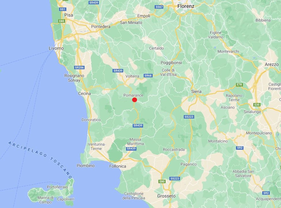
When Pope Pius V in 1596 created the approximately circular Granducato della Toscana, he must have had a compass at hand. He stuck the needle on Pomarance, the town of our holiday home. Indeed, from here it is about 100 km as the crow flies to the maximum extent of Tuscany, in all four cardinal directions. Most of the things to see in Tuscany are within a radius of 50 km. Therefore, the Agriturismo Podere Palazzone is the ideal starting point for exploring the region. For example, from our holiday home the distance as the crow flies to major sites are:
- 62 km to the Florence Cathedral
- 57 km to the Leaning Tower of Pisa
- 37 km to the Piazza del Campo in Siena
- 28 km to the beach of Cecina
- 60 km to the island of Elba.

Alternative to navigation apps: Tabula Peutingeriana
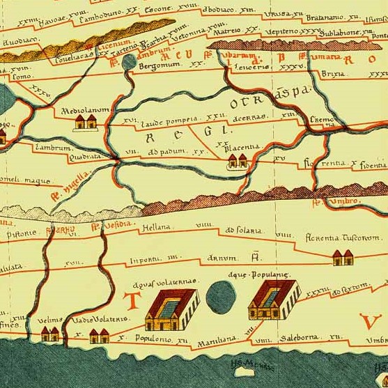
On the oldest map in the world, the Tabula Peutingeriana, our corner of Italy is already marked. While Florence, Siena or Milan are depicted with just two small houses, the town of Aquas Volaternas deserves a palace with an inner courtyard. According to the current state of historical science, this indicates the Complesso Sacro-Termale Etruso di Bagnone. It lies 20 km from our farm and was discovered only at the end of the 1980s. Here, the Etruscans used the healing waters of the natural hot springs. Bubbling warm water must have been a paramount experience at that time. Behind its healing power, the Etruscans suspected a divine power, as can be concluded from the manifold votive offerings found there. This place was a hotspot for the rich and beautiful, a wellness resort for the well-heeled. They certainly did not forego worldly pleasures here. Because they were far too fond of good food and music.
The Tabula Peutingeriana, a UNESCO World Document Heritage, is a medieval copy of a Roman road map. Although seven metres long, this world’s oldest surviving map is perhaps a little inaccurate compared to today’s map apps. But it is already amazingly complete. From Britannia to India, it spans the world as the Romans knew it. Indeed, the entire Roman road network is depicted, including horse-changing stations and daily distances between traffic junctions.
Follow us on Instagram:


We look forward to your message.
Holiday home Podere Palazzone in the heart of Tuscany
When Pope Pius V in 1596 created the approximately circular Granducato della Toscana, he must have had a compass at hand. He stuck the needle on Pomarance, the town of our holiday home. Indeed, from here it is about 100 km as the crow flies to the maximum extent of Tuscany, in all four cardinal directions. Most of the things to see in Tuscany are within a radius of 50 km. Therefore, the Agriturismo Podere Palazzone is the ideal starting point for exploring the region. For example, from our holiday home the distance as the crow flies to major sites are:
- 62 km to the Florence Cathedral
- 57 km to the Leaning Tower of Pisa
- 37 km to the Piazza del Campo in Siena
- 28 km to the beach of Cecina
- 60 km to the island of Elba.

An alternative to navigation apps:
The Tabula Peutingeriana
On the oldest map in the world, the Tabula Peutingeriana, our corner of Italy is already marked. While Florence, Siena or Milan are depicted with just two small houses, the town of Aquas Volaternas deserves a palace with an inner courtyard. According to the current state of historical science, this indicates the Complesso Sacro-Termale Etruso di Bagnone. It lies 20 km from our farm and was discovered only at the end of the 1980s. Here, the Etruscans used the healing waters of the natural hot springs. Bubbling warm water must have been a paramount experience at that time. Behind its healing power, the Etruscans suspected a divine power, as can be concluded from the manifold votive offerings found there. This place was a hotspot for the rich and beautiful, a wellness resort for the well-heeled. They certainly did not forego worldly pleasures here. Because they were far too fond of good food and music.
The Tabula Peutingeriana, a UNESCO World Document Heritage, is a medieval copy of a Roman road map. Although seven metres long, this world’s oldest surviving map is perhaps a little inaccurate compared to today’s map apps. But it is already amazingly complete. From Britannia to India, it spans the world as the Romans knew it. Indeed, the entire Roman road network is depicted, including horse-changing stations and daily distances between traffic junctions.
Follow us on Instagram:


